Fort McMurray Fire — Zero Percent Contained, 1.2 Million Acres in Size, and Crossing Border into Saskatchewan
The Fort McMurray Fire just keeps growing. A global warming fueled beast whose explosive expansion even the best efforts of more than 2,000 firefighters have been helpless to check.
*****
By mid-afternoon Thursday, reports were coming in that the Fort McMurray Fire had again grown larger. Jumping to 1.2 million acres in size, or about 2,000 square miles, the blaze leapt the border into Saskachewan even as it ran through forested lands surrounding crippled tar sand facilities. It’s a fire now approaching twice the size of Rhode Island. A single inferno that, by itself, has now consumed more land than every fire that burned throughout the whole of Alberta during 2015.

(Continued explosive growth of the Fort McMurray Fire shown graphically in the animation about. Image source: Natural Resources Canada.)
The fire has now encroached upon five towns and cities including Fort McMurray, Anzac, Lenarthur, Kinosis, and Cheeham. Tar Sands facilities encompassed by the blaze include Nexen’s Kinosis facility, CNOOC’s Long Lake, and Suncor’s Base Plant. Numerous other tar sands facilities now lie near the fire’s potential lines of further expansion. You can see the insane rate of growth for this fire in the animation above provided by the Natural Resources board of Canada.
Fort McMurray Continues to Prepare For Residents Return Despite Terrible Conditions
As the fire again expanded this week, reports coming out of Fort McMurray showed periods of horrendous air quality. Measures hit as high as 51 on Wednesday — which is five times a level that is considered ‘unsafe.’ Fires also ignited in a condo complex Thursday after a mysterious explosion claimed another Fort McMurray home on Tuesday. Embers falling from nearby large fires may have been the cause, but officials have so far provided no conclusive ignition source. For safety, emergency responders again shut off gas utilities in the city. Officials put on a brave face despite all the continued adversity, claiming that efforts to ready for a return of people to their homes were progressing.
Fire at Zero Percent Containment
Despite what is a massive firefighting effort, the enormous blaze remains zero percent contained. Firefighters have seen some success, however, in keeping fires from burning buildings in and around Fort McMurray through the constant application of water and through the building of enormous defensive fire breaks. With many trees near Fort McMurray and tar sands facilities already consumed by fire and with winds expected to shift toward the North and West, the blazes are expected to mostly move away from structures by Thursday evening. A welcome relief after fires on Tuesday and Wednesday burned down worker barracks in the tar sands production zone.

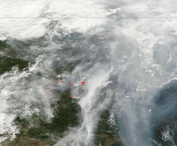
(Massive pall of smoke visible over Fort McMurray Fire in Saskatchewan and Alberta. For reference, bottom edge of frame is 250 miles. Image source: LANCE MODIS.)
With cooler weather and a 60 percent chance of rain today, fire conditions may abate somewhat. Rain predicted on Saturday could also aid in firefighting efforts. However, it is likely that this massive fire will continue to burn over Alberta and Saskatchewan throughout a good part of the summer.
Conditions in the Context of Human-Caused Climate Change
Fossil fuel burning is the primary source of the currently extreme carbon emissions that are now fueling the wrenching climate changes and increasingly severe wildfires in Canada. And such burning will almost certainly push 2016 to new record hot global temperatures in the range of 1.3 C above 1880s values. These new temperature extremes have contributed to a combination of factors including a comparatively rapid warming of Canada, permafrost thaw, tree death, and strong ridge formation that have all lead to a greater potential for dangerous wildfires.
Fort McMurray itself now sits firmly under a northbound flow of airs invading the polar region. Such powerful meridional flows feature much warmer than normal air temperatures and heightened risk for drought and wildfires. These zones have formed over recent years due to a weakening of the Jet Stream — which has been set off by sea ice loss and an assymetric warming of the High Arctic. Such polar amplification has also set off permafrost thaw, aided in pine beetle expansion northward toward and into the Arctic zone, and generated temperatures hotter than the range in which boreal forests typically survive and grow. Permafrost thaw combines with tree death to produce added fuels for fires even as warming provides more lightning strike ignition sources. This combination of global warming related factors has resulted in large wildfires occurring in the Arctic at 10 times their mid 20th Century ignition rate and is aiding in a greatly increased risk of fire throughout the boreal forest zone.
Links:
Fort McMurray Fire Crosses Border into Saskatchewan
LANCE MODIS
Natural Resources Canada
Hat tip to Greg
Hat tip to DT Lange
Hat tip to Wili
Hat tip to Colorado Bob
Thanks to: https://robertscribbler.com
The Fort McMurray Fire just keeps growing. A global warming fueled beast whose explosive expansion even the best efforts of more than 2,000 firefighters have been helpless to check.
*****
By mid-afternoon Thursday, reports were coming in that the Fort McMurray Fire had again grown larger. Jumping to 1.2 million acres in size, or about 2,000 square miles, the blaze leapt the border into Saskachewan even as it ran through forested lands surrounding crippled tar sand facilities. It’s a fire now approaching twice the size of Rhode Island. A single inferno that, by itself, has now consumed more land than every fire that burned throughout the whole of Alberta during 2015.

(Continued explosive growth of the Fort McMurray Fire shown graphically in the animation about. Image source: Natural Resources Canada.)
The fire has now encroached upon five towns and cities including Fort McMurray, Anzac, Lenarthur, Kinosis, and Cheeham. Tar Sands facilities encompassed by the blaze include Nexen’s Kinosis facility, CNOOC’s Long Lake, and Suncor’s Base Plant. Numerous other tar sands facilities now lie near the fire’s potential lines of further expansion. You can see the insane rate of growth for this fire in the animation above provided by the Natural Resources board of Canada.
Fort McMurray Continues to Prepare For Residents Return Despite Terrible Conditions
As the fire again expanded this week, reports coming out of Fort McMurray showed periods of horrendous air quality. Measures hit as high as 51 on Wednesday — which is five times a level that is considered ‘unsafe.’ Fires also ignited in a condo complex Thursday after a mysterious explosion claimed another Fort McMurray home on Tuesday. Embers falling from nearby large fires may have been the cause, but officials have so far provided no conclusive ignition source. For safety, emergency responders again shut off gas utilities in the city. Officials put on a brave face despite all the continued adversity, claiming that efforts to ready for a return of people to their homes were progressing.
Fire at Zero Percent Containment
Despite what is a massive firefighting effort, the enormous blaze remains zero percent contained. Firefighters have seen some success, however, in keeping fires from burning buildings in and around Fort McMurray through the constant application of water and through the building of enormous defensive fire breaks. With many trees near Fort McMurray and tar sands facilities already consumed by fire and with winds expected to shift toward the North and West, the blazes are expected to mostly move away from structures by Thursday evening. A welcome relief after fires on Tuesday and Wednesday burned down worker barracks in the tar sands production zone.

(Massive pall of smoke visible over Fort McMurray Fire in Saskatchewan and Alberta. For reference, bottom edge of frame is 250 miles. Image source: LANCE MODIS.)
With cooler weather and a 60 percent chance of rain today, fire conditions may abate somewhat. Rain predicted on Saturday could also aid in firefighting efforts. However, it is likely that this massive fire will continue to burn over Alberta and Saskatchewan throughout a good part of the summer.
Conditions in the Context of Human-Caused Climate Change
Fossil fuel burning is the primary source of the currently extreme carbon emissions that are now fueling the wrenching climate changes and increasingly severe wildfires in Canada. And such burning will almost certainly push 2016 to new record hot global temperatures in the range of 1.3 C above 1880s values. These new temperature extremes have contributed to a combination of factors including a comparatively rapid warming of Canada, permafrost thaw, tree death, and strong ridge formation that have all lead to a greater potential for dangerous wildfires.
Fort McMurray itself now sits firmly under a northbound flow of airs invading the polar region. Such powerful meridional flows feature much warmer than normal air temperatures and heightened risk for drought and wildfires. These zones have formed over recent years due to a weakening of the Jet Stream — which has been set off by sea ice loss and an assymetric warming of the High Arctic. Such polar amplification has also set off permafrost thaw, aided in pine beetle expansion northward toward and into the Arctic zone, and generated temperatures hotter than the range in which boreal forests typically survive and grow. Permafrost thaw combines with tree death to produce added fuels for fires even as warming provides more lightning strike ignition sources. This combination of global warming related factors has resulted in large wildfires occurring in the Arctic at 10 times their mid 20th Century ignition rate and is aiding in a greatly increased risk of fire throughout the boreal forest zone.
Links:
Fort McMurray Fire Crosses Border into Saskatchewan
LANCE MODIS
Natural Resources Canada
Hat tip to Greg
Hat tip to DT Lange
Hat tip to Wili
Hat tip to Colorado Bob
Thanks to: https://robertscribbler.com


 Sat Mar 23, 2024 11:33 pm by globalturbo

