The Mars Pathfinder and Viking Missions to Mars – A Photo Comparison
July 12, 2020 ~ Robert Morningstar

Official Description of The Pathfinder Mission
From NASA History
Mars Pathfinder was launched on December 4, 1996 at 1:58:07 am EST on a Delta II rocket. After an uneventful journey, the spacecraft safely landed on the surface of Mars on July 4, 1997.
Its landing on the Ares Vallis plain was confirmed at 1:07 p.m. EDT. The air bag landing system, tested at Glenn’s Plum Brook Station in Sandusky, Ohio, performed well.
The first set of data was received shortly after 5:00 p.m. followed by the release of images at 9:30 p.m.
The Sojourner Rover, with three Lewis components, then began its Martian trek and returned images and other data over the course of three months.
After operating on the surface of Mars three times longer than expected and returning a tremendous amount of new information about the red planet, NASA’s Mars Pathfinder mission completed the last successful data transmission cycle from Pathfinder at 6:23 a.m. EDT on Sept. 27, 1997. Source: https://www.nasa.gov/centers/glenn/about/history/marspath.html
 Pathfinder “Imp Mania”
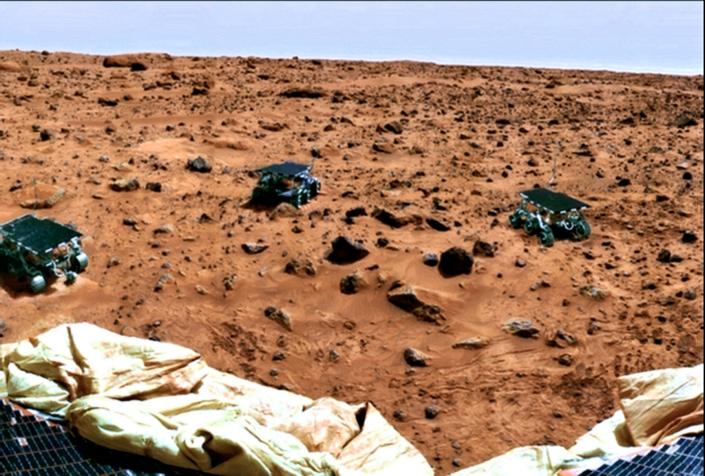
Robert Morningstar describes this discovery by Ron Gerbron as an example of “NASA DisInformation Technology”, namely, photo editing techniques intended to hide significant features and details that NASA wished to maintain obscured, or camouflaged.
This photo with the multiple rovers (dubbed by Ron Gerbron “Pathfinder Imp Mania“) is from one pan NASA released that they’d placed a Sojourner next to for all the “rocks” it visited.
Paradoxically, that is the only pan which wasn’t a crooked pile of mis-aligned patches, so I took a piece from it where there weren’t any rover tags, just to show what the rubble on the ground looks like.
 B &W “Half Dome” Pathfnder Image
  THE VIEW FROM THE SURFACE
The colors in this slide have been computer enhanced in order to show the details of the martian surface. As a result, the colors shown here do not precisely represent those that a human observer would see on Mars.
Source; https://www.lpi.usra.edu/publications/slidesets/redplanet2/slide_32.html
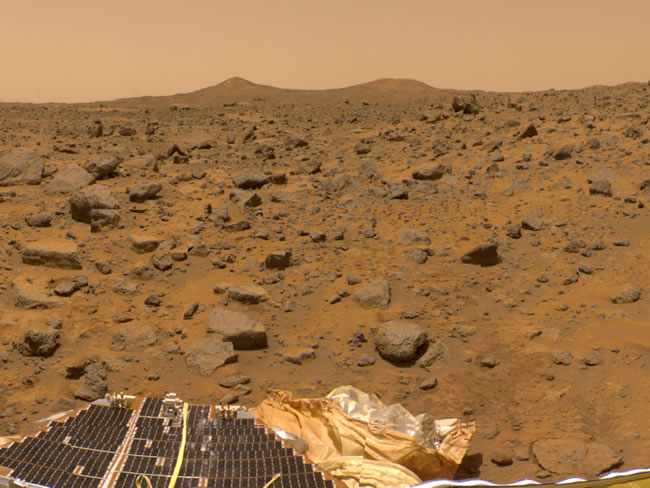
32. Mars Pathfinder: Twin Peaks (19°N,34°W)
This image shows the view to the west of the Pathfinder landing site. At the bottom, portions of the spacecraft’s solar panels and airbags are visible. Pathfinder landed in the outflow region of the Ares Vallis, an outflow channel similar to Maja Valles (slide #24). Many rocks are visible in this image and may have been transported to this region by massive floods early in the history of Mars. A pair of hills known as “Twin Peaks,” located about 1 kilometer from the Pathfinder lander, can be seen on the horizon. It is thought that the Twin Peaks may be a small-scale version of the streamlined deposits shown in slide #25. The streamlined crater deposits in slide #25 are about 150 kilometers northeast of the Pathfinder landing site but are part of the same outflow channel system. As with the previous slide, this slide is actually a mosaic of many individual images, and there are some misalignments visible in the mosaic.
Mars Pathfinder image 81957
Right click here to download a high-resolution version of the image (3.52 MB) AN ARTIST’S RENDERING OF MARS PATHFINDER, WHICH CONSISTED OF A LANDER AND THE FIRST-EVER ROBOTIC ROVER ON THE SURFACE OF THE RED PLANET.
scitechdaily.com/the-pathfinders-trains-lens-on-daring-mission-to-mars/
 Viking Lander Photo for Camparison with Pathfinder Photos
Utopia on Mars
Credit:
The Viking Project, M. Dale-Bannister WU StL, NASA
Explanation: The Viking 2 spacecraft was launched on the Road to Utopia in September of 1975 (30 years after Bing, Dotty, and Bob). In August of 1976, after making the second successful Martian landing, Viking 2’s lander began recording data used to produce this exquisitely detailed image of the Martian surface in the area of Utopia Planitia (the Plain of Utopia).
Visible at the lower right are the protective shroud that covered the lander’s soil collector head, ejected after the descent, along with one of the lander’s dust covered footpads. Seen near the center are shallow trenches dug by the sampler arm. Mars looks red because its surface is covered with reddish iron oxide dust (rust). This dust, suspended in the thin carbon dioxide atmosphere, also filters the sunlight causing surface views to take on a reddish tinge.
The Vikings made the first successful landings on Mars 20 years ago. What does Mars look like today?
Source: APOD – Astronomy Picture of the Day
http://apod.nasa.gov/apod/ap960722.html
https://ufospotlight.wordpress.com/2020/07/12/the-mars-pathfinder-mission-a-photo-analysis/
Thanks to: https://ufospotlight.wordpress.com
July 12, 2020 ~ Robert Morningstar

The Mars Pathfinder
&
Viking Missions to Mars
A Photo ComparisonBy Ron Gerbron & Robert Morningstar
(Copyright 2020, R. Gerbron-& R.D. Morningstar-All Rights Reserved)Official Description of The Pathfinder Mission
From NASA History
Mars Pathfinder was launched on December 4, 1996 at 1:58:07 am EST on a Delta II rocket. After an uneventful journey, the spacecraft safely landed on the surface of Mars on July 4, 1997.
Its landing on the Ares Vallis plain was confirmed at 1:07 p.m. EDT. The air bag landing system, tested at Glenn’s Plum Brook Station in Sandusky, Ohio, performed well.
The first set of data was received shortly after 5:00 p.m. followed by the release of images at 9:30 p.m.
The Sojourner Rover, with three Lewis components, then began its Martian trek and returned images and other data over the course of three months.
After operating on the surface of Mars three times longer than expected and returning a tremendous amount of new information about the red planet, NASA’s Mars Pathfinder mission completed the last successful data transmission cycle from Pathfinder at 6:23 a.m. EDT on Sept. 27, 1997. Source: https://www.nasa.gov/centers/glenn/about/history/marspath.html
 Pathfinder “Imp Mania”
Robert Morningstar describes this discovery by Ron Gerbron as an example of “NASA DisInformation Technology”
This photo with the multiple rovers (dubbed by Ron Gerbron “Pathfinder Imp Mania“) is from one pan NASA released that they’d placed a Sojourner next to for all the “rocks” it visited.
Paradoxically, that is the only pan which wasn’t a crooked pile of mis-aligned patches
 B &W “Half Dome” Pathfnder Image
  THE VIEW FROM THE SURFACE
The colors in this slide have been computer enhanced in order to show the details of the martian surface. As a result, the colors shown here do not precisely represent those that a human observer would see on Mars.
Source; https://www.lpi.usra.edu/publications/slidesets/redplanet2/slide_32.html
32. Mars Pathfinder: Twin Peaks (19°N,34°W)
This image shows the view to the west of the Pathfinder landing site. At the bottom, portions of the spacecraft’s solar panels and airbags are visible. Pathfinder landed in the outflow region of the Ares Vallis, an outflow channel similar to Maja Valles (slide #24). Many rocks are visible in this image and may have been transported to this region by massive floods early in the history of Mars. A pair of hills known as “Twin Peaks,” located about 1 kilometer from the Pathfinder lander, can be seen on the horizon. It is thought that the Twin Peaks may be a small-scale version of the streamlined deposits shown in slide #25. The streamlined crater deposits in slide #25 are about 150 kilometers northeast of the Pathfinder landing site but are part of the same outflow channel system. As with the previous slide, this slide is actually a mosaic of many individual images, and there are some misalignments visible in the mosaic.
Mars Pathfinder image 81957
Right click here to download a high-resolution version of the image (3.52 MB)
 AN ARTIST’S RENDERING OF MARS PATHFINDER, WHICH CONSISTED OF A LANDER AND THE FIRST-EVER ROBOTIC ROVER ON THE SURFACE OF THE RED PLANET.
 THIS DOCUMENTARY “THE PATHFINDERS”
TELLS THE STORY BEHIND THE MISSION
CREDIT: NASA/JPL-CALTECHscitechdaily.com/the-pathfinders-trains-lens-on-daring-mission-to-mars/
 Viking Lander Photo for Camparison with Pathfinder Photos
Utopia on Mars
Credit:
The Viking Project, M. Dale-Bannister WU StL, NASA
Explanation: The Viking 2 spacecraft was launched on the Road to Utopia in September of 1975 (30 years after Bing, Dotty, and Bob). In August of 1976, after making the second successful Martian landing, Viking 2’s lander began recording data used to produce this exquisitely detailed image of the Martian surface in the area of Utopia Planitia (the Plain of Utopia).
Visible at the lower right are the protective shroud that covered the lander’s soil collector head, ejected after the descent, along with one of the lander’s dust covered footpads. Seen near the center are shallow trenches dug by the sampler arm. Mars looks red because its surface is covered with reddish iron oxide dust (rust). This dust, suspended in the thin carbon dioxide atmosphere, also filters the sunlight causing surface views to take on a reddish tinge.
The Vikings made the first successful landings on Mars 20 years ago. What does Mars look like today?
Source: APOD – Astronomy Picture of the Day
http://apod.nasa.gov/apod/ap960722.html
https://ufospotlight.wordpress.com/2020/07/12/the-mars-pathfinder-mission-a-photo-analysis/
Thanks to: https://ufospotlight.wordpress.com


 Sat Mar 23, 2024 11:33 pm by globalturbo

