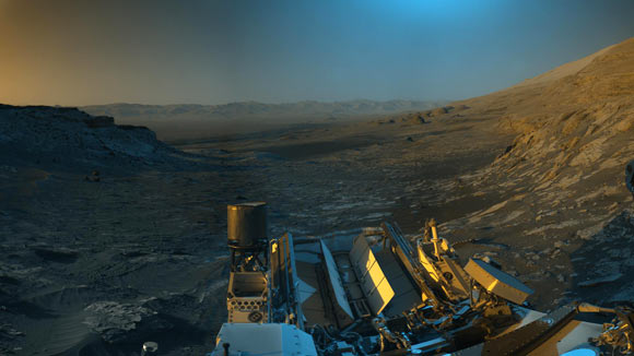
Curiosity Team Releases Stunning Panorama of Martian Landscape
Nov 26, 2021 by News Staff / Source
Members of NASA’s Curiosity rover mission team have combined two versions of the black-and-white images of Martian mountains from different times of the day and added colors to create a rare postcard from Mars.

Curiosity used its navigation cameras to capture panoramas of this scene at two times of day. Image credit: NASA / JPL-Caltech.
On November 16, 2021, the Curiosity team commanded the rover to take two sets of composite images, capturing the scene at 8:30 a.m. and again at 4:10 p.m. local Mars time.
The two times of day provided contrasting lighting conditions that brought out a variety of landscape details.
The researchers then combined the two scenes in an artistic re-creation that includes elements from the morning scene in blue, the afternoon scene in orange, and a combination of both in green.
“Curiosity captures a 360-degree view of its surroundings with its black-and-white navigation cameras each time it completes a drive,” they explained.
“To make the resulting panorama easier to send to Earth, the rover keeps it in a compressed, low-quality format.”
“But when we saw the view from rover’s most recent stopping point, the scene was just too pretty not to capture it in the highest quality that the navigation cameras are capable of.”
“The blue, orange, and green tints are not what the human eye would see; instead, they represent the scene as viewed at different times of day.”
At the center of the panorama is the view back down Mount Sharp, the 5-km- (3-mile) tall mountain that Curiosity has been driving up since 2014. Rounded hills can be seen in the distance at center-right.
A field of sand ripples known as the ‘Sands of Forvie’ stretches 400 to 800 m (1,300-2,600 feet) away.
At the far right of the panorama is the craggy ‘Rafael Navarro Mountain,’ named after a Curiosity team scientist who passed away earlier this year.
Poking up behind it is the upper part of Mount Sharp, far above the area Curiosity is exploring.
Mount Sharp lies inside Gale Crater, a 154-km- (96-mile) wide basin formed by an ancient impact.
Gale Crater’s distant rim stands 2.3 km (7,500 feet) tall, and is visible on the horizon about 30 to 40 km (18 to 25 miles) away.
_____
This article is based on text provided by the National Aeronautics and Space Administration.
http://www.sci-news.com/space/curiosity-panorama-10310.html?utm_source=feedburner&utm_medium=email
Thanks to: http://www.sci-news.com
Nov 26, 2021 by News Staff / Source
Members of NASA’s Curiosity rover mission team have combined two versions of the black-and-white images of Martian mountains from different times of the day and added colors to create a rare postcard from Mars.

Curiosity used its navigation cameras to capture panoramas of this scene at two times of day. Image credit: NASA / JPL-Caltech.
On November 16, 2021, the Curiosity team commanded the rover to take two sets of composite images, capturing the scene at 8:30 a.m. and again at 4:10 p.m. local Mars time.
The two times of day provided contrasting lighting conditions that brought out a variety of landscape details.
The researchers then combined the two scenes in an artistic re-creation that includes elements from the morning scene in blue, the afternoon scene in orange, and a combination of both in green.
“Curiosity captures a 360-degree view of its surroundings with its black-and-white navigation cameras each time it completes a drive,” they explained.
“To make the resulting panorama easier to send to Earth, the rover keeps it in a compressed, low-quality format.”
“But when we saw the view from rover’s most recent stopping point, the scene was just too pretty not to capture it in the highest quality that the navigation cameras are capable of.”
“The blue, orange, and green tints are not what the human eye would see; instead, they represent the scene as viewed at different times of day.”
At the center of the panorama is the view back down Mount Sharp, the 5-km- (3-mile) tall mountain that Curiosity has been driving up since 2014. Rounded hills can be seen in the distance at center-right.
A field of sand ripples known as the ‘Sands of Forvie’ stretches 400 to 800 m (1,300-2,600 feet) away.
At the far right of the panorama is the craggy ‘Rafael Navarro Mountain,’ named after a Curiosity team scientist who passed away earlier this year.
Poking up behind it is the upper part of Mount Sharp, far above the area Curiosity is exploring.
Mount Sharp lies inside Gale Crater, a 154-km- (96-mile) wide basin formed by an ancient impact.
Gale Crater’s distant rim stands 2.3 km (7,500 feet) tall, and is visible on the horizon about 30 to 40 km (18 to 25 miles) away.
_____
This article is based on text provided by the National Aeronautics and Space Administration.
http://www.sci-news.com/space/curiosity-panorama-10310.html?utm_source=feedburner&utm_medium=email
Thanks to: http://www.sci-news.com


 Sat Mar 23, 2024 11:33 pm by globalturbo

