Ancient Antenna Found At the Bottom of Antarctica’s Sea: Eltanin Antenna
by Universe Inside You
https://youtu.be/Lx82xEQPBzY
Year after year, researchers stumble on some unexplained mysteries in Antarctica that shock mainstream historians and archaeologists.
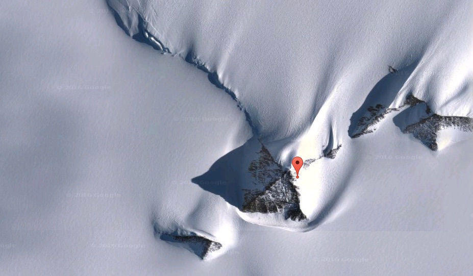
From the alledged three pyramids that perfectly resemble the pyramids at Giza to the dozens of strange objects detected by satellite images, Antarctica continues to be Earth’s least explored continent.
That can’t be a surprise, considering it’s the most remote place from any human civilization, and it’s buried under at least three miles of ice, almost five kilometers. It’s the coldest, highest, windiest, and driest place on the planet, making it nearly impossible for archaeological excavation and exploration without spending millions of dollars. No wonder we know so little about it.

This leads many to believe in the possibility that at some point in the distant past, Antarctica was home to Earth’s oldest civilization and that all the strange discoveries spotted there are scarce reminisce of its existence. Of course, scientists can’t dig the three miles of ice and explore it thoroughly, but does that mean that no one knows what lies beneath the ice?
It was very surprising that the map depicted North and South America with extreme detail. Although America was already discovered 21 years earlier, it was not mapped with such precision until much later. This made Piri Reis’s map the oldest surviving detailed map of the Americas. The map even depicted the Andes mountains, which were first sighted 14 years later by Francisco Pizarro.
What really shocked scholars was that the Piri Reis map also revealed the continent of Antarctica, and not only that, but it depicted it before it was covered with ice. No one could explain how this was possible, considering the fact that mainland Antarctica was discovered in 1820 and it was by then long covered with ice.
Apparently, Piri Reis didn’t create the map entirely by himself. Instead, he used the vast library of Constantinople, which was now in possession of the Ottomans. There, he uncovered different ancient maps from old civilizations like the Egyptians, Greeks, and Indians, together with six other sources Piri Reis didn’t want to disclose. From where these civilizations took the knowledge of the geography of Antarctica when it was without ice, and who the other six sources are is still a mystery.
Many people believe these civilizations received this knowledge from much older sources. Sources left from perhaps the first civilization that existed on the Earth. A culture living in Antarctica in a time when there was no ice and the continent was warm and full of life and vegetation.
Even if we assume that navigators sailed down the coast of America, Africa, and Antarctica to map it, then the Piri Reis map should indicate only the coastal features. Yet, the map accurately portrays mountains, rivers, and deep land features, which cannot be known without detailed exploration.
It was not until 2004 and 2007 when a detailed sonar radar surveyed Antarctica and scanned the topographical features of the landscape beneath the ice cap. Astonishingly, the Piri Reis map depicted all of these features beneath the ice.
Many people consider the map as evidence that an ancient advanced civilization existed millions of years ago and depicted Antarctica or that some kind of extraterrestrial contact brought this knowledge to the ancients.
Whatever the case, we may never know what really lies beneath the 3 miles of ice in Antarctica, but perhaps we don’t need to look under the ice. What if we look at the bottom of the sea near the coastline instead? What can we find there?
In the next two years, the ship brought plenty of data previously unknown and shed much light on our knowledge of the region. There were, however, a few mysteries spotted at the bottom of the ocean.
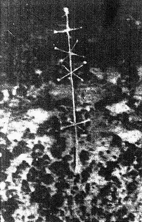
One of them was discovered on August 29, 1964, when the USNS Eltanin was photographing the ocean floor west of Cape Horn at a depth of almost 3 miles. What they discovered was astonishing. There, along the primarily bare bottom of the sea, they managed to take pictures of a bizarre structure standing in the middle of nowhere.

The structure was very symmetrical, standing at 2 feet high, and had nodules, spokes, and protrusions ending in a spherical node. It resembled an antenna or some other kind of signal transmitter.
When the New Zealand Herald first released the photographs on December 5, 1964, in an article titled “Puzzle Picture From Sea Bed,” scientists and researchers were immediately stunned.
MORE HERE: https://universe-inside-you.com/eltanin-antenna/
Thanks to: https://universe-inside-you.com
by Universe Inside You
https://youtu.be/Lx82xEQPBzY
Year after year, researchers stumble on some unexplained mysteries in Antarctica that shock mainstream historians and archaeologists.
From the alledged three pyramids that perfectly resemble the pyramids at Giza to the dozens of strange objects detected by satellite images, Antarctica continues to be Earth’s least explored continent.
That can’t be a surprise, considering it’s the most remote place from any human civilization, and it’s buried under at least three miles of ice, almost five kilometers. It’s the coldest, highest, windiest, and driest place on the planet, making it nearly impossible for archaeological excavation and exploration without spending millions of dollars. No wonder we know so little about it.

Antarctica – A Tropical Paradise
The little we do know about it, however, is as surprising as ever. Fossil records reveal that millions of years ago, Antarctica was like a paradise – warm and covered in tropical jungles, forests, lakes, vegetation, and all sorts of wildlife.This leads many to believe in the possibility that at some point in the distant past, Antarctica was home to Earth’s oldest civilization and that all the strange discoveries spotted there are scarce reminisce of its existence. Of course, scientists can’t dig the three miles of ice and explore it thoroughly, but does that mean that no one knows what lies beneath the ice?
The Piri Reis Map and Antarctica
Apparently not, because in late 1929, a German theologian working in Istanbul, Turkey, found a gazelle-skin parchment that had a map drawn on it. The map was from 1513 and was drawn and signed by an Ottoman admiral and cartographer by the name of Ahmed Muhiddin Piri, later known as Piri Reis.It was very surprising that the map depicted North and South America with extreme detail. Although America was already discovered 21 years earlier, it was not mapped with such precision until much later. This made Piri Reis’s map the oldest surviving detailed map of the Americas. The map even depicted the Andes mountains, which were first sighted 14 years later by Francisco Pizarro.
What really shocked scholars was that the Piri Reis map also revealed the continent of Antarctica, and not only that, but it depicted it before it was covered with ice. No one could explain how this was possible, considering the fact that mainland Antarctica was discovered in 1820 and it was by then long covered with ice.
Apparently, Piri Reis didn’t create the map entirely by himself. Instead, he used the vast library of Constantinople, which was now in possession of the Ottomans. There, he uncovered different ancient maps from old civilizations like the Egyptians, Greeks, and Indians, together with six other sources Piri Reis didn’t want to disclose. From where these civilizations took the knowledge of the geography of Antarctica when it was without ice, and who the other six sources are is still a mystery.
Many people believe these civilizations received this knowledge from much older sources. Sources left from perhaps the first civilization that existed on the Earth. A culture living in Antarctica in a time when there was no ice and the continent was warm and full of life and vegetation.
Even if we assume that navigators sailed down the coast of America, Africa, and Antarctica to map it, then the Piri Reis map should indicate only the coastal features. Yet, the map accurately portrays mountains, rivers, and deep land features, which cannot be known without detailed exploration.
It was not until 2004 and 2007 when a detailed sonar radar surveyed Antarctica and scanned the topographical features of the landscape beneath the ice cap. Astonishingly, the Piri Reis map depicted all of these features beneath the ice.
Many people consider the map as evidence that an ancient advanced civilization existed millions of years ago and depicted Antarctica or that some kind of extraterrestrial contact brought this knowledge to the ancients.
Whatever the case, we may never know what really lies beneath the 3 miles of ice in Antarctica, but perhaps we don’t need to look under the ice. What if we look at the bottom of the sea near the coastline instead? What can we find there?
The Eltanin Antenna
In 1962, the National Science Foundation of the US created a technologically advanced oceanographic research vessel called the USNS Eltanin. It was the world’s first geophysical ship tasked with exploring Antarctica and the waters surrounding it.In the next two years, the ship brought plenty of data previously unknown and shed much light on our knowledge of the region. There were, however, a few mysteries spotted at the bottom of the ocean.
One of them was discovered on August 29, 1964, when the USNS Eltanin was photographing the ocean floor west of Cape Horn at a depth of almost 3 miles. What they discovered was astonishing. There, along the primarily bare bottom of the sea, they managed to take pictures of a bizarre structure standing in the middle of nowhere.

The structure was very symmetrical, standing at 2 feet high, and had nodules, spokes, and protrusions ending in a spherical node. It resembled an antenna or some other kind of signal transmitter.
When the New Zealand Herald first released the photographs on December 5, 1964, in an article titled “Puzzle Picture From Sea Bed,” scientists and researchers were immediately stunned.
MORE HERE: https://universe-inside-you.com/eltanin-antenna/
Thanks to: https://universe-inside-you.com


 Sat Mar 23, 2024 11:33 pm by globalturbo

